Highgear TrailDrop User Manual
Page 3
2
3
engl
sh
english
S3
S1
S2
S4
S3
T
H
E R
M A - S E N
S O
R
N
W
W
SW
S
S
E
E
NE
N
BE
AR
IN
G
N
E
X
T
/S
TA
RT
/S
PLI
T
MO
DE
/S
E
L
E
C
T
S
E
T
/ S
TO
P
/ L
IG
HT
PM
T1
S4
S3
S1
S2
LIGHT BUTTON
To activate flashlight LED
To read compass press
S1 at any time.
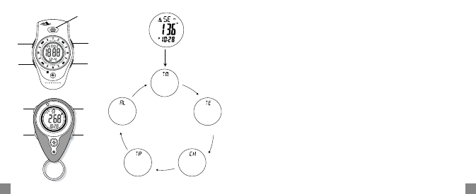
TIME
TEMPERATURE
CHRONO
TIMER
ALARM
HOW TO USE ELECTRONIC COMPASS FEATURE
Compass must be calibrated before first use.
Press S1 to take compass reading. For accurate reading, make sure to level the
compass using the level bubble.
CAUTION: The Digital Compass function is very sensitive to magnetic and elec-
tric fields. The direction will be affected by nearby magnetic or electronic
devices.
CALIBRATION: Allows user to align the Compass magnetic sensor with the
earth’s magnetic field so that the Compass can detect the correct direction. With
the declination angle added, the magnetic North will be adjusted by the clock-
wise shift or anti-clockwise shift of this angle, giving you the true North reading.
The range of declination angle is 00 E to 99 E and 00 W to 99 W. The declination
angles for major world cities are listed on the following page.
DECLINATION: The difference in degrees, or angle, between North and mag-
netic North.
TRUE NORTH: Also, known as geographic North, this is map North (North Pole)
MAGNETIC NORTH: The geographical region toward which all magnetic nee-
dles point. This point is 1300 miles south of the North. (This is why it’s important
to calibrate!)
The declination angles for major world cities are included.