Highgear Axis User Manual
Page 14
ALTIWARE SERIES
TABLE OF CONTENTS
25
english
axis
TABLE OF CONTENTS
26
english
CHANGE ALTITUDE UNITS
Change the display units for altitude between Feet and Meters
using a
PRESS & HOLD
of the
S2
key. Continue to hold the key
until the altitude units icon stops flashing.
MAX/ACC SCROLLING MESSAGE
When you enter the ALTIMETER mode, the top line of the display
will show your MAXIMUM and ACCUMULATED ALTITUDE
since the last time you cleared the memories.
NOTE:
To skip the scrolling message,
QUICK PRESS
the
S1
,
S2
or
S5
keys.
NOTE:
To see MAXIMUM and ACCUMULATED
ALTITUDES during use,
QUICK
PRESS
the
S1
key
To CLEAR the MAXIMUM AND ACCUMULATED
MEMORIES, see Set Altimeter section.
ALTITUDE LOCK
If the altitude does not change significantly for a period of 30-
minutes the Axis will automatically activate the ALTITUDE LOCK
function. ALTITUDE LOCK is INDICATED by the weather icons
appearing on the altimeter display. When the unit enters the
Altitude Lock mode, the altitude at that time is locked in memory
and will not change in response to gradual external barometric
pressure changes. You can unlock the Altitude Lock function at
any time simply by pressing any key. The Altitude Lock function
will automatically deactivate if it detects any major change in
pressure/altitude over a short period of time.
ALTIMETER
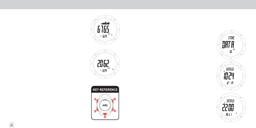
ALTIMETER DATA LOG MEMORY
STORING DATA POINTS
At any time in the Altitude display,
PRESS
AND
HOLD
the
S1
key
for a period of approximately 3-seconds. During this time the top line
of the display will show the word STORE, and DATA will flash in the
middle line with the number of the Data Point appearing in the lower
display line.
When the Data has been stored in memory, the top line will change
from STORE to STORED. Release the
S1
key and the unit will return to
the altitude display after approximately 2-seconds.
RETRIEVING DATA INFORMATION
Advance to the ALTITUDE DATA (Alti DATA) using
QUICK
PRESSES
of the
S3
key. The top line of the display will show the file number,
the middle and bottom lines will show the time and date the file was
captured. Every 3 seconds the display will change to show the Altitude
of the file in the middle line and Alti in the lower line. The user may
also manually advance the display usng the
S5
key. Use a
QUICK
PRESS
of the
S1
or
S2
keys to move through multiple captured files.
The number of the file will always be shown in the upper line of the
display. The file system works on a First-In Last–Out system, where the
newest files are the ones with the highest file numbers.
The Axis is equipped with an Altitude Data Point memory system. This system allows you to capture
to memory the altitude of a particular location along with the date and time of the capture. The Axis is
capable of storing up to 20 individual Altitude Data Points.