Linx Technologies RXM-GPS-SR User Manual
Page 6
Page 11
Page 10
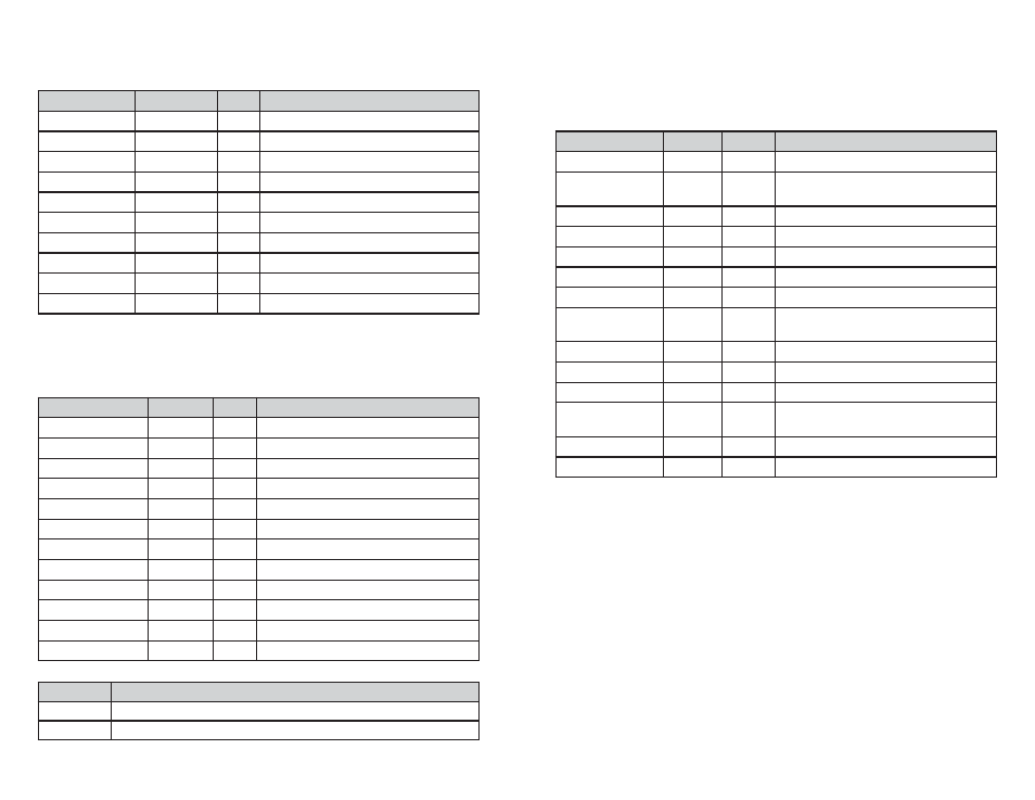
GSV – GNSS Satellites in View
The table below contains the values for the following example:
$GPGSV,3,1,12,28,81,285,42,24,67,302,46,31,54,354,,20,51,077,46*73
$GPGSV,3,2,12,17,41,328,45,07,32,315,45,04,31,250,40,11,25,046,41*75
$GPGSV,3,3,12,08,22,214,38,27,08,190,16,19,05,092,33,23,04,127,*7B
1. Depending on the number of satellites tracked, multiple messages of GSV data may be required.
Name
Example
Units
Description
Message ID
$GPGSV
GSV protocol header
Total number of
messages
1
3
Range 1 to 3
Message number
1
1
Range 1 to 3
Satellites in view
12
Satellite ID
28
Channel 1 (Range 01 to 32)
Elevation
81
degrees Channel 1 (Range 00 to 90)
Azimuth
285
degrees Channel 1 (Range 000 to 359)
SNR (C/No)
42
dB-Hz
Channel 1 (Range 00 to 99, null when
not tracking)
Satellite ID
20
Channel 4 (Range 01 to 32)
Elevation
51
degrees Channel 4 (Range 00 to 90)
Azimuth
77
degrees Channel 4 (Range 000 to 359)
SNR (C/No)
46
dB-Hz
Channel 4 (Range 00 to 99, null when
not tracking)
Checksum
*73
<CR> <LF>
End of message termination
Table 7: GNSS Satellites in View Example
GLL – Geographic Position – Latitude / Longitude
The table below contains the values for the following example:
$GPGLL,2503.6319,N,12136.0099,E,053740.000,A,A*52
GSA – GNSS DOP and Active Satellites
The table below contains the values for the following example:
$GPGSA,A,3,24,07,17,11,28,08,20,04,,,,,2.0,1.1,1.7*35
Name
Example
Units
Description
Message ID
$GPGLL
GLL protocol header
Latitude
2503.6319
ddmm.mmmm
N/S indicator
N
N=north or S=south
Longitude
12136.0099
dddmm.mmmm
E/W indicator
E
E=east or W=west
UTC Time
053740
hhmmss.sss
Status
A
A=data valid or V=data not valid
Mode
A
A=autonomous, D=DGPS
Checksum
*52
<CR> <LF>
End of message termination
Name
Example
Units
Description
Message ID
$GPGSA
GSA protocol header
Mode1
A
See Table 7
Mode 2
3
1=No Fix, 2=2D, 3=3D
ID of satellite used
24
Sv on Channel 1
ID of satellite used
7
Sv on Channel 2
...
...
ID of satellite used
Sv on Channel 12
PDOP
2
Position Dilution of Precision
HDOP
1.1
Horizontal Dilution of Precision
VDOP
1.7
Vertical Dilution of Precision
Checksum
*35
<CR> <LF>
End of message termination
Table 4: Geographic Position – Latitude / Longitude Example
Table 5: GNSS DOP and Active Satellites Example
Value
Description
M
Manual - forced to operate in 2D or 3D mode
A
Automatic - allowed to automatically switch 2D/3D
Table 6: Mode1 Values