The map display, Calling up the map display, Structure of the map display – Becker TRAFFIC ASSIST Z100 Crocodile User Manual
Page 58: Map display without route guidance, Map display with route guidance, Navigation mode
58
>>>
NAVIGATION MODE
> D
> GB
> F
> I
> E
> P
> NL
> DK
> S
> N
> FIN
> TR
> GR
> PL
> CZ
> H
> SK
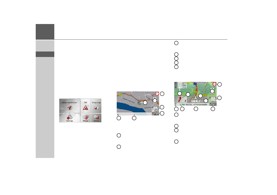
The map display
The map display is used primarily for
route guidance. However, you can also use
the map display without route guidance to
show your current position and, for exam-
ple, to receive warnings about exceeding
the speed limit.
Calling up the map display
The map display is called up automatical-
ly when you start route guidance.
Without route guidance, you can call up
the map display from the main menu.
> In the main menu, press
Show map
.
The map display will then appear and, if
GPS reception is available, will show your
current position.
If route guidance is already active, the
map will be displayed with route guid-
ance.
Structure of the map display
The structure depends on whether route
guidance is active or not.
Map display without route guidance
If the navigation is not active, almost the
whole area of the touch screen will be tak-
en up by the map.
Speed limit on the road currently be-
ing driven on (display not available
for all roads)
Zoom buttons
Information box showing compass,
vehicle speed and altitude above sea
level
Button for calling up the options
Current road
Vehicle position
Display power level / Display TMC
setting
Map display with route guidance
Speed limit on the road currently be-
ing driven on (display not available
for all roads)
Zoom buttons
Information box showing compass,
vehicle speed and altitude above sea
level
Button for calling up the options
1
2
3
6
4
5
7
1
2
3
4
5
6
7
1
2
6
5
10
3
7
11
8
4
9
1
2
3
4
- TRAFFIC ASSIST Z099 TRAFFIC ASSIST Z098 TRAFFIC ASSIST Z201 TRAFFIC ASSIST Z107 TRAFFIC ASSIST Z108 TRAFFIC ASSIST Z109 TRAFFIC ASSIST Z102 TRAFFIC ASSIST Z103 TRAFFIC ASSIST Z203 TRAFFIC ASSIST Z202 TRAFFIC ASSIST Z204 TRAFFIC ASSIST Z205 TRAFFIC ASSIST Z213 TRAFFIC ASSIST Z215 TRAFFIC ASSIST Z217 TRAFFIC ASSIST Z112 TRAFFIC ASSIST Z113 TRAFFIC ASSIST Z116