Route guidance with arrow display, Using the map display, Map zooming – Becker MAP PILOT OPERATION GUIDE User Manual
Page 36: Navigation mode
36
>>>
NAVIGATION MODE
> D
> GB
> F
> I
> E
> P
> NL
> DK
> S
> N
> FIN
> TR
> GR
> PL
> CZ
> H
> RUS
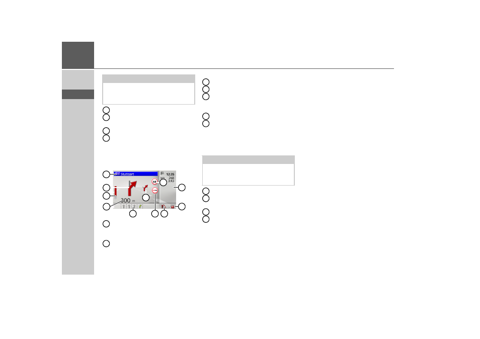
Distance to next driving manoeuvre
Progress bar to illustrate the distance
to the next driving manoeuvre
Next driving manoeuvre
Estimated time of arrival, remaining
journey time and remaining distance
to destination
Route guidance with arrow display
Estimated time of arrival, remaining
journey time and remaining distance
to destination
Number of satellites currently being
received
Display of TMC status
Driver alerts
Speed limit on the road currently be-
ing driven on (display not available
for all roads)
Next driving manoeuvre but one
Current road
or
Traffic lane recommendation (only
appears on some multi-lane roads;
green arrows = recommended lanes)
Distance to next driving manoeuvre
Progress bar to illustrate the distance
to the next driving manoeuvre
Next driving manoeuvre
Road signs, which you should follow
Using the map display
Map zooming
If the Autozoom function is enabled as de-
scribed under “Map display” on page 42
or “Autozoom” on page 47, the map is en-
larged or reduced according to these set-
tings.
However, you can also enlarge or reduce
the map at any time during route guid-
ance by turning the rotary control/push
button. The Autozoom function is then
disabled until the next maneuver is
reached or for the duration of 60 seconds.
The current map scale is shown in the
bottom right of the map display.
Note:
Following the traffic lane recommenda-
tions allows you to perform the next driv-
ing manoeuvre without changing lanes.
8
9
10
11
11
8
5
9
6
10
1
2
3
4
7
8
1
2
Note:
Following the traffic lane recommenda-
tions allows you to perform the next driv-
ing manoeuvre without changing lanes.
3
4
5
6
7
8
9
10
11