Intellinav 1 User Manual
Page 14
26
Intellinav One User’
s Manual
Route Options
The route options give you control over the navigation
of your trip. You can change the following:
Method
Ferries
Toll Roads
Carpool
Turns
There are four method settings. Quickest calculates the
route that should take the least amount of time. Major
calculates a route that uses major roads whenever
possible. Shortest calculates the route that is shortest in
distance. Local calculates a route that uses local roads
whenever possible.
The ferries setting indicates whether ferries should be
included when your route is calculated. If you include
ferries, the route will take you to the ferry terminal, but
the total time for the route does not take into account
the ferry schedule or time spent on the ferry.
The toll roads setting indicates whether you want to
include or exclude toll roads when your route is
calculated. If you include toll roads, those roads will be
used if appropriate for the method you selected.
The carpool setting indicates whether or not you want to
include carpool or high occupancy vehicle (HOV)
restrictions in the calculation of your route.
The turns setting indicates whether or not you want to
make more or less turns.
T
To
o sse
ett yyo
ou
urr rro
ou
utte
e sse
ettttiin
ng
gss::
1. Tap M
Me
en
nu
u. The main menu appears.
2. Tap R
Ro
ou
utte
e O
Op
pttiio
on
nss. The Route Options screen
appears.
3. Tap your Method preference: Q
Qu
uiicckke
esstt, M
Maajjo
orr,
S
Sh
ho
orrtte
esstt, or LLo
occaall.
4. Tap your Ferries preference: IIn
nccllu
ud
de
e or E
Exxccllu
ud
de
e.
5. Tap your Toll Roads preference: IIn
nccllu
ud
de
e or E
Exxccllu
ud
de
e.
6. Tap your Carpool preference: IIn
nccllu
ud
de
e or E
Exxccllu
ud
de
e.
7. Tap your Turns preference: R
Re
ed
du
ucce
ed
d or N
No
orrm
maall.
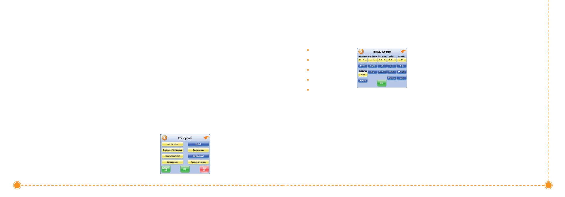
The 3D view settings control your view of the map. Off
shows you the map in traditional 2D mode. High,
Medium, and Low show you a 3D version of the map,
with a different angle for each value. If you use any of
the 3D settings you will not be able to tap on a location
to view location information.
T
To
o sse
ett yyo
ou
urr d
diissp
pllaayy sse
ettttiin
ng
gss::
1. Tap M
Me
en
nu
u. The Menu button and then Settings.
2. Tap D
Diissp
pllaayy O
Op
pttiio
on
nss. The Display Options screen
appears.
3. Tap your Orientation preference: H
He
eaad
diin
ng
g or
N
No
orrtth
h.
4. Tap your Guidance preference: A
Au
utto
o or M
Maan
nu
uaall.
5. Tap your Day/Night preference: A
Au
utto
o, N
Niig
gh
htt, or
D
Daayy.
6. Tap your POI Icons preference: D
De
effaau
ulltt, O
Offff, or
C
Cu
usstto
om
m.
When you tap C
Cu
usstto
om
m the POI Options screen
appears.
a. Tap on the categories you want displayed.
The categories to be displayed are
highlighted.
b. You can use S
Se
elle
ecctt A
Allll and C
Clle
eaarr A
Allll to
quickly highlight or clear categories.
c. When you have highlighted the categories
you want displayed, tap O
OK
K. You return to
the Display Options screen.
7. Tap your Color preference: Y
Ye
ellllo
ow
w, G
Grre
eyy, W
Wh
hiitte
e, or
F
Fu
ucch
hssiiaa.
8. Tap your 3D View preference: 2
2D
D, H
Hiig
gh
h, M
Me
ed
diiu
um
m,
or LLo
ow
w.
9. When you have finished choosing your options, tap
O
OK
K..
25
User's Manual