Table 147: gga message output format – NavCom Sapphire Rev.J User Manual
Page 308
Sapphire Technical Reference Manual Rev. J
308
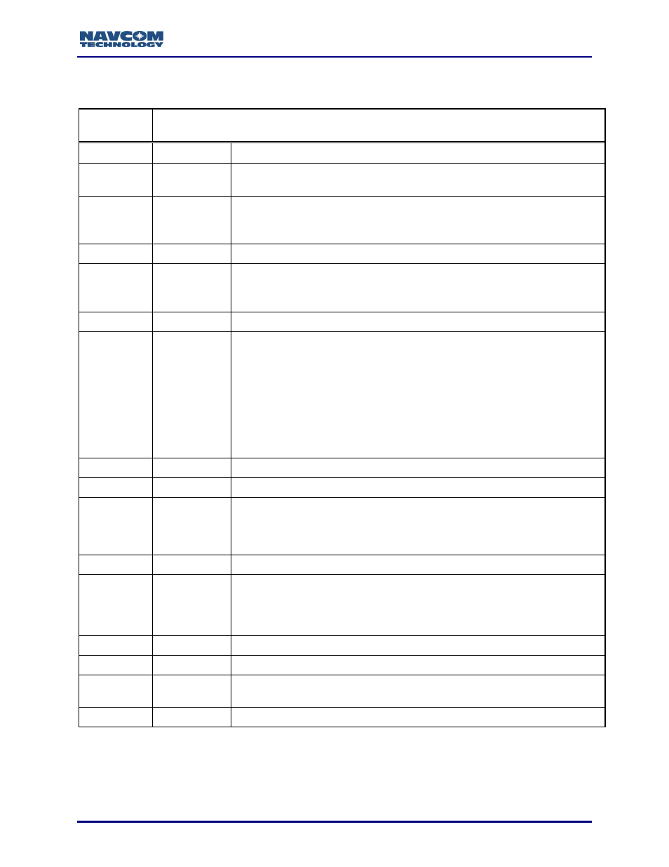
The output format for this message is described in Table 147.
Table 147: GGA Message Output Format
Output
Format:
$GPGGA,time,lat,N/S,lon,E/W,quality,used,hdop,alt,M,separation,M,age,id*checksum
Field#
Field Name
Description
F1
time
UTC time for position fix in hours, minutes, seconds (hhmmss.ss)
(000000.00 to 235959.99)
F2
Lat
NMEAGGA: Latitude in decimal degrees and minutes (ddmm.mmmm)
(0000.0000 to 8959.9999)
High precision: (ddmm.mmmmmm) (0 to 8959.999999)
F3
N/S
Direction of latitude (N=north, S=south)
F4
Lon
NMEAGGA: Longitude in decimal degrees and minutes (dddmm.mmmm)
(00000.0000 to 17959.9999)
High precision: (dddmm.mmmmmm) (0 to 17959.999999)
F5
E/W
Direction of longitude (E=east, W=west)
F6
quality
Quality of the position fix (0 to 8)
0 = fix not available, or invalid
1 = GPS SPS Mode, fix valid
2 = Differential GPS, SPS Mode, fix valid
3 = GPS PPS Mode, fix valid
4 = Real Time Kinematic, fixed integers
5 = Float RTK, floating integers
6 = estimated (dead reckoning) Mode
7 = Manual input mode
8 = Simulation mode
F7
used
Number of used satellites in the position fix, 00-12
F8
hdop
Horizontal Dilution of Precision, 1 (ideal) to >20 (poor)
F9
Alt
Altitude above mean sea level (geoidal height) in meters, a theoretical
value that for practical purposes can range from -50 or so for low places
on Earth, to very large positive values for the heights. NMEAGGA: mm.m,
High precision: mm.mmm
F10
M
Units for altitude (M=meters)
F11
separation
Geoidal Separation: the difference between the WGS-84 earth ellipsoid
surface and mean-sea-level (geoid) surface, "-" = mean-sea-level surface
below WGS-84 ellipsoid surface.
Note: If no geoid is loaded, geoidal separation is reported as 0.
F12
M
Units for geoidal separation (M=meters)
F13
age
Time since last dGPS data was received, in seconds
F14
Id
Reference station ID number (0000
– 1023). In RTG mode this is the
StarFire satellite ID.
F15
*CRC
Checksum