NavCom StarUtil Rev.G User Manual
Page 54
StarUtil User Guide – Rev. G
SET refers to Solid Earth Tides. Positions with SET provide better vertical
(primarily) and horizontal positioning accuracy, to account for gravitational effec
placed
ts
on terrain from celestial bodies (i.e. the Sun, Moon, etc.).
The SET message output via the NMEA port is a NavCom proprietary NMEA type
message. It conforms to the header, checksum, and electrical characteristics of a
standard NMEA string, but is not recognized by the NMEA governing body as an
officially sanctioned message. Refer to Appendix A, Table 12 for a detailed description of
the NMEA Type message structure.
Navigation
Elevation Mask
Tracking
Elevation Mask
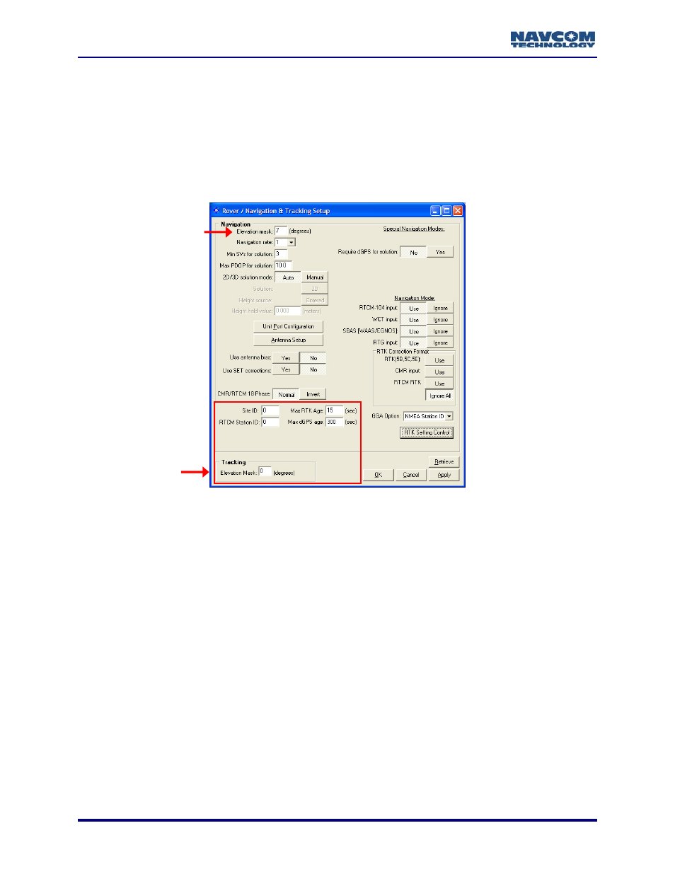
Figure 47: Rover / Navigation & Tracking Setup Window
Refer to Figure 47 for the options below:
• Site ID: The default 0 configures the rover to accept RTK corrections from any base
station. Enter a specific Site ID to accept RTK corrections only from the base station with
the same Site ID. The default Site ID on the Base Configuration window is 3 (see
Figure 33).
• Max RTK Age: Enter the maximum amount of time in seconds the received correction
will be used in case of an outage or drop in the reception of corrections. The time must
be within the max RTK age limit, which is 60 seconds. The default is 15 seconds. If the
age is less than the rate of corrections received, the rover will not enter RTK mode.
• Max dGPS Age: Enter the maximum amount of time in seconds the received correction
will be used in case of an outage or drop in the reception of corrections. The time must
be within the max dGPS age limit, which is 1200 seconds. The default is 300 seconds.
• Tracking/Elevation Mask: Enter a value to set the elevation angle at which the receiver
will start tracking satellites. The default is 0. The valid range is between 0 and 90
degrees, but a value higher than 10 is not recommended. The GPS data from the
tracked satellites is not added to the navigation solution. In contrast, the
Navigation/Elevation Mask setting sets the elevation angle at which the
processing GPS data to
receiver will start
be added to the navigation solution.
5-52